Search This Blog

Wednesday, February 26, 2014

February 23, 2014 Carlsbad, NM

Sunday, February 23

Walked the campground a bit - I now understand where "quick as a bunny" comes from, as the rabbits I tried to photograph nearly always vanished before I could snap a shot!

We saw some deer near a water tower on our way out of the campground.


Headed to Carlsbad Caverns early as we hoped to be there as it opened.  Paused for a few photographs of these barbary sheep which were around a cave in the rocky hillside.


 Reached the Caverns just after opening and opted to take the elevator down to the big room for the self-guided tour.   Simply amazing.  13 football fields would fit inside and much of the cavern is decorated with various formations.   The cavern is dimly lit, with the existing lighting placed to highlight various formations.  We saw other travelers once in a while, but felt alone much of the time because of the quiet and cool, vast spaces.


Some formations are still actively forming (and wet) and a ranger said that the occassional drop of water that we might feel on our head probably was from a rain last Fall.  There are myriad other chambers and tunnels, some of which have yet to be explored and charted.


Spent about 3 hours at Carlsbad and then began the long haul back to Houston.   Dropped down to I-10 and set cruise control.  We did stop for dinner and a break at CrackerBarrel in Kerrville.

Arrived home about 12:40 PM after a total of 3, 780 miles and countless oooh's, ahh's, wow's and smiles.  What a wonder full world!

Saturday, February 22

30 degrees this morning and temperature dropped for a while as we headed to Carrizozo. Sunrise arrived softly in pastel blues, pinks and yellows.
Carrizozo's faint lights at dawn.
This town had painted donkeys throughout….add that to our list of painted animals including horses, cows, bears, dolphins, groundhogs…  Carrizozo's other claim to fame is that it is where the movie Book of Eli with Denzel Washington was filmed. From here we headed south on Rt 54 to Alamagordo and White Sands.

As we approached Alamagordo we began to see Pistachio orchards and vineyards. Several roadside stands but they weren't open yet.

pistachio orchards

On to White Sands.  Arrived at 8:10 and the Dunes Road was happily open.  There was a scouting event going on in one area with a few hundred people, but not a lot of tourists otherwise.
visitor's center at White Sands.

We drove the loop and did a few short walks into the dunes.  Of those in the park, many were sliding down dunes on saucer-type sleds or, as in photo below, burying people!  Though the sun was shining, it was still quite chilly and the sand was cold.


  One trail was marked by orange posts so that hikers wouldn't get lost.  Talked with a few photographers doing time-lapse photos, and tried to capture the gracefulness and beauty of the dunes on a few (lol) photos of our own.


As with so much of the terrain this trip, the sheer vastness and grandeur is difficult to capture.

We headed back up Rt 54 a bit and stopped for some tasty samples and nuts at PistachioLand, which is next to one of the largest orchards in NM.

We then turned eastward again and made the steep climb to aptly named Cloudcroft.  Passed the Apple Barn and an interesting RR Trestle on the 4000' climb.  Some snow as we neared the highest elevation, but not on the roads.  Temperature predictably dropped over 15 degrees as we climbed.


Continued across NM towards Carlsbad, and decided to stay at Brantley Lake State Park for the night.
NM State parks are a bargain at $14 for a site with electric and showers!  This park must be an oasis for rabbits, too, as we spotted quite a few cottontails along with a long-earred jack rabbit.

The lake looked to be quite large, surrounded by scrubby brush and small trees. Some interesting dried thistles.

The strong winds that we had lost in White Sands (thankfully) reappeared.

There was a star party that evening hosted by two rangers, but because of clouds, the only thing we really saw was Jupiter with its rings and moons.


Monday, February 24, 2014

Friday, February 21

Although the weather channel called for a low of 36 around Payson,  the temperature continued to fall and was 23 degrees at 6:45AM.  We ran the heater a few times during the night to keep things warm.
We decided to head across Arizona and New Mexico by smaller roads rather than taking major highways.  Lots of trees, patches of snow, evidence of logging and some fires.  Up and down mountains.  A far cry from the desert down south! Temperature up to 33 by 8:45.

Reached the White Mountains and took a few  side roads to explore.  One went south into the Apache Indian Reservation and  Williams Creek Fish Hatchery where  they raise Apache Trout, a local endangered species, as well as browns and rainbows. 

Back onto White Mountain Scenic Highway, we stopped at A-1 Lake, elevation 8700’.
It was just beginning to thaw and there was a good bit of snow.


We stopped for gas at a town called Eagar and enjoyed lunch at an Arby’s across the street.  Out of the mountains, we entered White Mountains Grassland Wildlife area – golden grasses, small trees and rolling hills for miles and miles.  We crossed into New Mexico and saw a herd of antelope just before Pie Town. (A tiny town with a few enterprising folks selling pie.)


Next stop was the Nat’l Radio Astronomy Observatory VLA – Very Large Array about 40 miles before Socorro.  This is an arrangement of 27 white, 230 ton dish antennas  spread over 22 miles, gathering radio waves to explore black holes, planets, and space. The antennas all work together and use fiber optics and a super computer to provide data.  Interesting visitor’s center and tour.


Were going to stop at Water Canyon to camp but after talking to a local sheriff, we decided to continue on to Socorro for warmer temps, boondocking at Walmart there.


Feb 19,2014 Grand Canyon

Wednesday, February 19

Woke early to 31 degrees and Greg couldn’t go back to sleep so we hit the road at 4:00, figuring it would give us a full day at the Grand Canyon.  They were predicting colder weather later in the week, so we plan to do Sedona after the GC.  We are finding that altitude is the biggest factor in nighttime temps and since we haven't winterized the Trek (anti-freeze in the water lines, etc.) we are seeking lower altitudes at night.

Temp dropped to a low of 20 degrees as we climbed towards Flagstaff.  At a little town called Strawberry we saw a herd of elk crossing the highway. Brown and grey shadows with buff rears scattered along both sides of the road.  There were some patches of snow along the highway, and a few more elk.  Stopped for coffee and gas in Flagstaff,  
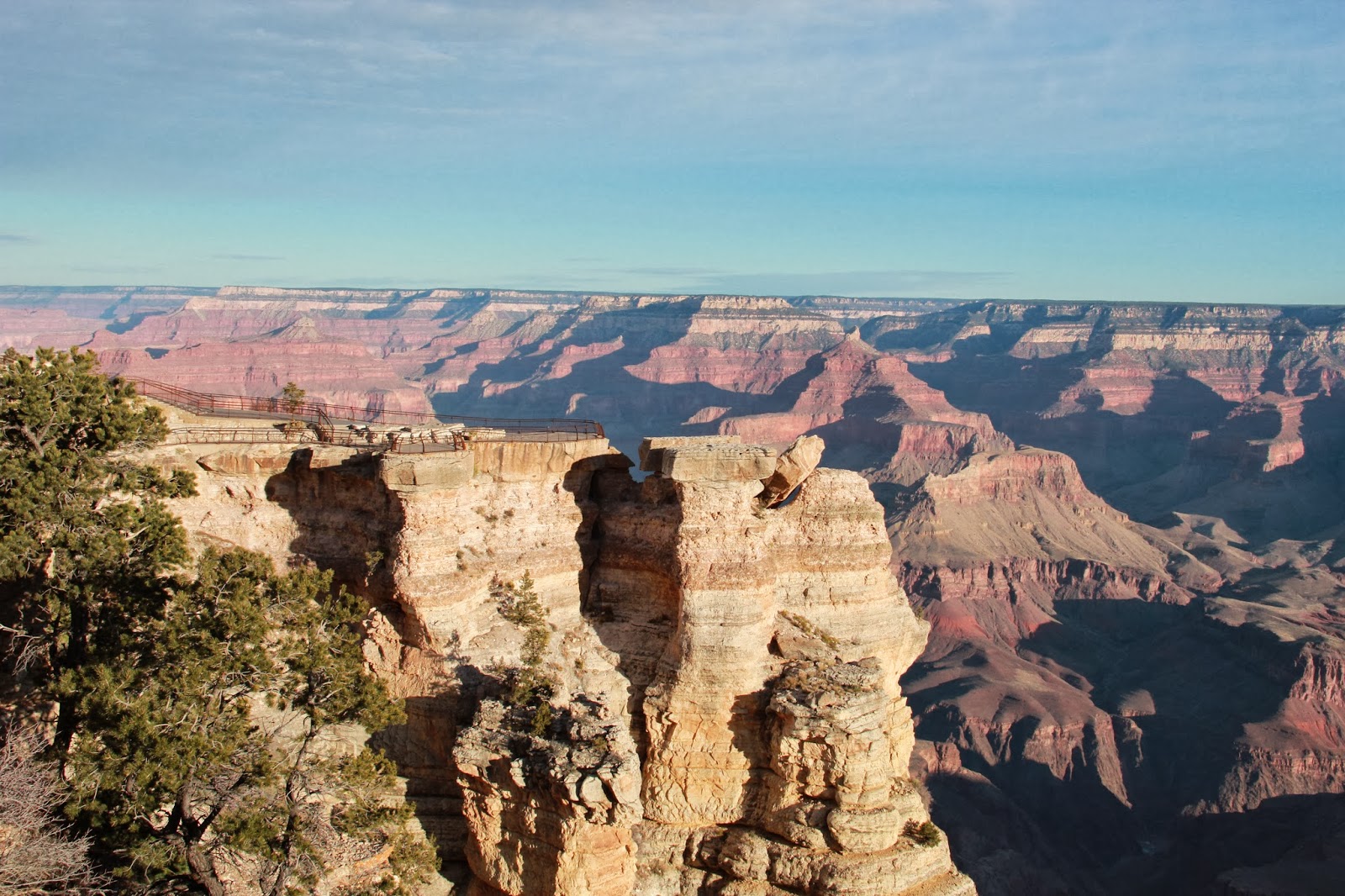
and arrived at the Grand Canyon just after sunrise – 7:25.  Parked at GC Village and walked (quickly - very cold and windy!) to Mather’s Point and a few other viewpoints along the canyon.

 Sunrise en route to Grand Canyon.


Decided to drive Hermit’s Rest Road, which is only open to vehicles from December to the end of February.  Beautiful overlooks every few miles and we had it to ourselves for the first two hours.  Even then it wasn’t crowded and we had no trouble with parking.  Got clearer as we went and we could see Mt. Trumbul which was 80+ miles away.


Saw a couple of elk.  Went back through the village and headed east, stopping at the trail to Shoshoni Point that we had discovered last visit (2005?).  Sunny and much warmer (54) by noon, but still windy.


We both like the sculpture of the twisted trees.

Shoshone Point. What a view!


A few more stops, then we exited the park around 1:00 and headed south towards Flagstaff and Sunset Crater Volcano National Monument.  The wind was fierce and the dust in the distance was amazing.  Lots of tumbleweeds blowing across the road!
Colorado River about a mile below the rim.

 Dust in the distance. Greg wrestled a bit to keep the Trek on the road!


When we reached the Visitor’s Center at Sunset Crater, they said wind gusts were up to 40mph there.  This is an area which still shows signs of the volcanoes that erupted here long ago….lots of lava rock and cinders.  We walked a short trail and then continued South. The ranger at Sunset Crater suggested Cottonwood, so that is where we are headed.
Cinder covered mts.
Lava rock.


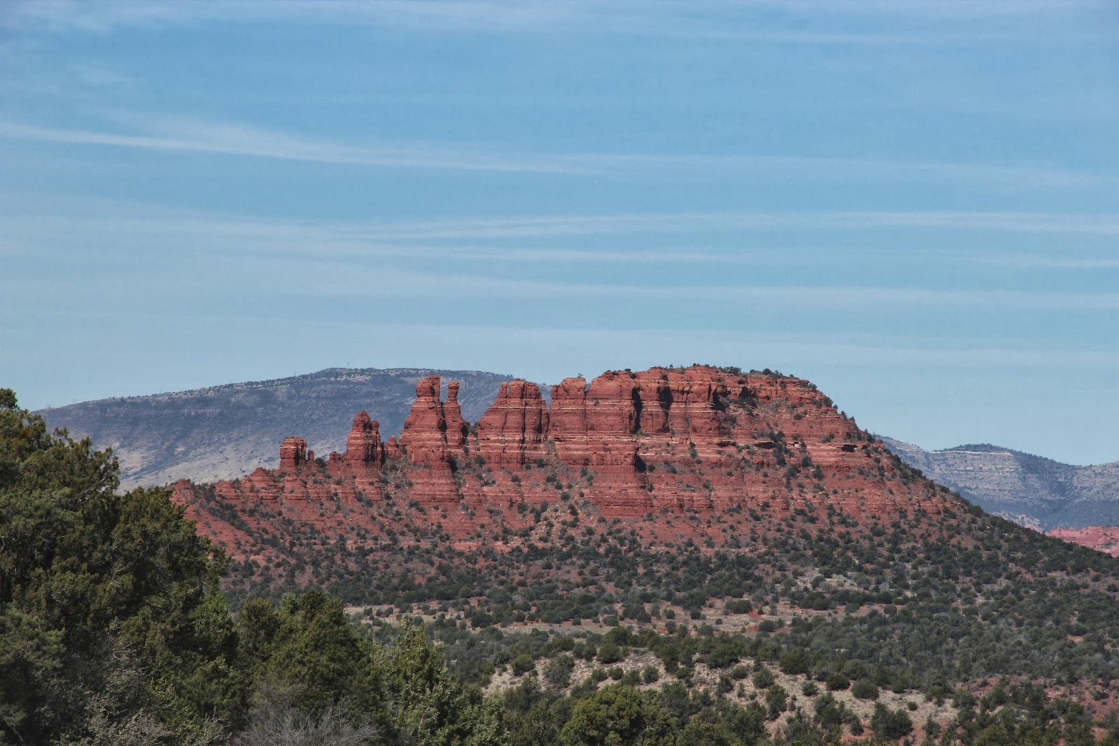
Came through scenic Oak Creek Canyon, 89A, and into Sedona, going from  over 7,000 ft elevation in the San Francisco Mts. to less than 4,000. Lots of southwest architecture, red rock, yellow rock, adobe, pinion pines, some ponderosa pines against a gorgeous blue sky. Beautiful. 


Continued south to Cottonwood and Dead Horse Ranch State Park. Nice campgrounds, we stayed in number 45 (close to the rest rooms and hot showers)! Long day…. Had dinner and called it a night.


Thursday, February  20
Had a leisurely wake-up, shower and breakfast before we set out to explore Sedona and the area they call Red Rock Country. 

First stop was a fish hatchery just up the road where we spotted this bald eagle – and his choice of breakfast!  It was on Page Springs Road, which had a lot of water and birds, something we haven't seen in a while.


 Next we did the Red Rock Lower and Upper Loop, which winds through some great scenery.  Some really nice homes too, many of which are adobe but far from simple.


 We continued up 89A to Boyton Canyon and Boyton Pass Loop.  Beautiful area with towering rock formations.  We were going to do the whole Loop, but part of the road was extremely rough so we called it quits after about a mile and backtracked to the Canyon.

Parked here and walked the Vista Trail.  Very busy place, lots of people hiking.  Beautiful day but very windy when you got up high – hold on to your hat!  A man in the parking lot gave me a red rock heart and told me this place has incredible energy and I could take the energy with me in this rock.   For those who believe in chakra and energy, vortex, and that sort of thing,  this is a very sacred place. 


 Next we went into Sedona and looked for a place for lunch.  We asked a young man for a recommendation and went to his suggestion – Wildflower Bread, which is very similar to Pannera Bread, and was quite tastey. We enjoyed eating outside in the warm sun. Visited a few nearby stores – quite a lot of art, clothing and other shops and galleries.  Bought a beautiful hummingbird at The Hummingbird House, which had this sculpture in front.  The restaurant we ate at is in the background.
 
 Headed southwest to a beautiful Chapel of the Holy Cross, built into the red rocks.  Beautiful, simple and very busy.  We parked and walked up a long drive with our heads on a swivel!
 
 Chapel of the Holy Cross.
 Greg walking up to the Chapel.


 Chapel interior.


Decided to head east after this and re-visit our boondocking spot at Flowing Springs.  This time we found 2 other campers – one, a couple from the Yukon, were planning to spend a few days and “air out” their dog which was recently “skunked”!  Ah! The outdoor life!

Greg built a nice fire .  We looked at pictures and snacked a bit.