Tuesday, September 14
Hurricane IDA came through Houston last night and there are still remnants this morning. There was a fair amount of rain and wind, but not too bad for us. We decided to go ahead with our plans to leave this morning, but Greg did some clean-up first, clearing the driveway of pine needles and cones, leaves, twigs and such and picking up things from the yard. A couple of trash bags full!
We pulled out around 8:00 with a light mist and some gusty winds, which continued as we headed north on I-45. Heavy cloud cover kept temperatures cool till about Fort Worth. Then blue skies gradually took over and it was around 90 when we arrived at the Comfort Inn in Amarillo a little after 6:00. This drive is getting a little old....ranchland, wind turbines, oil pumps and a whole lot of flat.
We walked to a nearby Red Robin for dinner, showered and settled in for the night. Had to call the front desk to figure out how to work their shower. There was a ring inside the tub faucet that you pulled down to activate the shower - that's a new one on us!
Wednesday, September 15
Grab and go breakfast of breakfast bars and muffins with coffee. (Still no sit-down eating due to COVID.) Then we gassed up and headed northwest on the Ports to Plains highway, #87, which runs from the Gulf Coast up to the Panhandle. Familiar countryside, as we have done this route before to get out of Texas when heading west. Not a bad road and it is often paralleled by train tracks.
Cotton, cattle, lots of irrigation. Some oil jack pumps and tanks, scrubby flats until more irrigation and then lots of soy beans and sorghum, etc. along with cattle.
Grain silos everywhere. Can't help but wonder what climate change will do to this area (and much of the west) since water is so integral!
We twisted through the Texas panhandle, then past old volcano cinder cones (this is Capulin)
and rocky mesas as we eased into the northeast corner of New Mexico. Saw a few grazing antelope. We stopped at Sugarite Canyon State Park. We were able to reserve a site by phone, the only option; though we had to drive a couple of miles to get cell signal.
First stop was the Visitor's Center where a ranger was just arriving to open things. Donned masks and went inside. Pat Walsh, the ranger, recommended a few trails, the first of which was the nearby Coal Camp Trail, a winding 2 mile or so walk through the stone remains of a coal camp that existed here from the 1920's through the 1940's. Hard to imagine a bustling area with men, women and children in today's hardscrabble landscape!
The mine openings had been blocked and have since caved in and gone back to nature. Irish, Czechs, Swedes, Mexicans - quite a variety of folks worked together under some pretty awful conditions. Building foundations from schools, shops and homes were barely visible and abandoned equipment scattered about. At one point a sign pointed to a "gob" - quite a disappointment as it was no tasty treat, but a pile of debris and leftover "stuff".
This is the remains of the dynamite shack.

Even though it was noon-ish and the sun was shining, the elevation made it quite pleasant, though I sure could tell we weren't at 30 feet above sea level any more, particularly when going up hill! (aka blame it on the elevation.)
Next we decided to find our campsite at Soda Pocket Campground, which was up a rough dirt road, atop a small mesa. Turns out this was a trip full of rough dirt roads. Nice breezes up there! Our site was #23. There was a fire ring and covered picnic table and some unidentified plant that smelled like sweet mint!

The top of the canyon was across from us. A few vultures were riding the air currents.
We decided to do another trail before dinner, so headed to the Lake Maloya Trail. There are two lakes here and fishing seemed popular. A few of summer's last flowers along the trail. (You didn't think you'd get away without seeing flowers, did you?)
Saw a few deer while driving back to our campsite. There are also bear, coyote, fox and a few other mammals in the area, mostly nocturnal. This park is dry, with few trees and mostly shrubs and grasses. Remnants of burned Ponderosa Pines dotted the hills from a fire 10 years ago. They aren't coming back - climate change? Beautiful bright half moon and many stars in the cool, clean, crisp air. Greg made a fire, which felt good as the temperature dropped. Chicken fajitas (from home) for dinner and a quiet evening.
Note: The road to the campground was a rough mile and a half, with the shaking causing a latch to fall off one cabinet, and when Greg opened another glass-front cabinet, the whole door came off! He was able to fix things with the help of gorilla glue and an extra screw. My McGyver!
Thursday, September 16
42 degrees this morning! The road north out of the park had been washed out, so we had to head south to get back to I-25 to go north into Colorado. Quick stop at the visitor's center which had nice clean, hot showers, and had breakfast in the Trek there.
Into Colorado we noticed a sign for the Ludlow Massacre Memorial, so decided to see what it was about. We were thinking native Americans, but it turns out to be mining-related. In 1913, miner's struck over unsafe working conditions. The mine owners evicted all those on strike and they set up tent cities with help from the fledgling United Mine Workers Union. (They dug basements under their tents to survive Colorado's winter!) Violence was not uncommon, and over twenty miners and their families were gunned down in their tents here.
This antelope was moseying nearby.

A bit of a shock when we got off I-25 near Pueblo to fill the gas tank. $3.79 a gallon! (Paid $2.64 in TX). Got a Subway sandwich for a late lunch and found 67N, our next adventure.
It is a gravel/dirt road which is part of the Gold Belt Tour, which goes through old mining territory and Phantom Canyon. Amazing canyons and 2 stone tunnels! The railroad used to run this route transporting gold from Cripple Creek and Victor areas. We stop at a dry wash to do a bit of rockhounding, finding some cool pieces with shiny specks - unfortunately I'm pretty sure it was mica, pyrite and quartz rather than gold and silver.Dry wash.
Tunnel #1
Tunnel #2. We stopped here in a spot of shade for lunch.

We are gradually gaining altitude and soon begin to see aspen with a suggestion of Fall color.

The road begins to narrow and we now better understand this sign that we saw earlier....
It gets worse as we go north, so that it soon becomes a single lane, rocky road curling around sharp bends. Can't tell from this picture but it is a sharp drop off over the edge! Good thing there isn't much traffic! There are some wide-ish spots now and then where vehicles could pass.

We finally reach the town of Victor and take some photos of historic as well as current mining operations.

The skies really are that blue!
Many of the buildings looked like early 1900's.
We called the local BLM (Bureau of Land Management) office about dispersed camping and they recommended going back down 67 for a few miles.
So we did, and found this comfortable spot in the canyon for a quiet night. It was on an unused small side road and we cleaned up some trash left by thoughtless earlier guests. Some people....!!!
The setting sun highlighted the rock wall across from us as we sat outside and enjoyed a salad with chicken.
This thistle shaped like a crown caught my eye.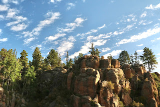


No comments:
Post a Comment