45 degrees this morning as we headed east into the sun,
towards Crater Lake National Park. I have heard wonderful things about this place so am a little worried that I'll be disappointed. The north entrance is still closed so we
had to drive quite a way down to the south entrance. But it was a gorgeous drive along the
Rogue-Umpqua Scenic Byway.
First we traveled many miles along the Northern Umpqua
River. There were quite a few fishermen
fishing for Steelhead. We are back into
rolling wooded hills interspersed with ranchland. Everything is green and the hills look
almost like they are carpeted.
We climb to Diamond Lake, which is about 5,000’ elevation and see snowmobile signs, “chain up” areas and tall poles that mark the road in the snow. But there are only a few patches of snow in shady spots.
We finally reach Hwy 62 which leads into Crater Lake. Heavily wooded and more snow as we
climb. Two deer leap across the road way
too close to us for my comfort!
We had called ahead, so knew that the one visitor’s center
was open but the rim drive around the crater and the visitor center at the rim
had not opened for the season yet. We
stopped at the Visitor’s center and watched a 20 minute film about the
formation of the lake from the explosion of Mount Mazama 7700 yrs ago. It holds 5 trillion gallons of the purest
water on earth, and has a beautiful blue color. No streams or rivers flow in or
out, the water comes from an average of 44’ of snow per year. It is 1943’ at its deepest, the deepest in
the US. It is 6 miles across at widest
point. This morning's clouds have mostly disappeared, leaving a wonderful sunny day.
The first view is awesome. Literally breathtaking.
The Rim Road was closed to vehicles, but open to walkers and
bikers, so Greg got our bikes ready and we road for a few miles. Fantastic views! Unfortunately, we are used to biking at 38’
not at 6000+’ and Beth had some problems on the hills – like not being able to
breathe and headaches.
Lots of snow. We
arrived pretty early but by the time we were leaving there were quite a few
people, including a group from Mexico that included the man in this Mexican
Indian costume.
On the way out there were some interesting formations from volcanic times included these which were formed by steam when lava hit ground water.
We head east and north to see Fort Rock which someone told us about at a viewpoint. We passed a large marsh which had some interesting birds, like a yellow-headed blackbird and magpies and ducks.
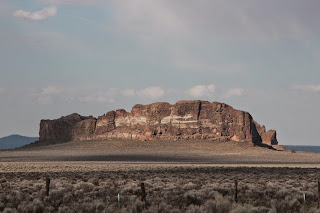
Fort Rock was formed by a Tuff Ring during volcanic
times . From a distance it resembles a butte or mesa, but when you drive around
you can see that it is a ring of rock.
Amazing that no matter where we go, there are some sort of flowers flourishing!
We took 31 (the
Oregon Outback Scenic Highway) back to highway 97. Young forest mixed with
sagebrush and rolling hills. We stop
for gas in the town of La Pine and Greg chats with the attendant. (It is a law in Oregon that service stations
must pump gas for their customers. ) He
tells us a nearby street to take into the country where there is BLM land and
National Forest where we can do “dispersed camping” – boondocking. We find a spot off of a gravel road leading
to Finley Butte. Dinner and goodnight!


The lake photos are some of my very favorite yet!
ReplyDeleteKathy
absolutely beautiful!!!!
ReplyDelete