Search This Blog

Thursday, March 10, 2022

2/22/22 St Francisville, LA to home

 2/22/22

We stop by a McD's for a breakfast sandwich and coffee before heading towards St. Francisville, north of Baton Rouge.  Beth has read about some of their plantations and has heard nice things about the town.  

We take 55North (another scenic byway) and continue to see evidence of storm damage. Blue tarps on roofs and broken off trees.  Between hurricanes and tornadoes, this area has been hard hit in the past few years!  

We head for Rosedown Plantation which is supposedly one of the most beautifully restored plantations.  Unfortunately, we won't be able to verify this because when we pull up to the entry gates there is a sign saying they are closed for a private event.  Their website mentioned nothing about this, so I call to double check and let them know we're unhappy.  We are there at their supposed opening time and we see three other cars pull in and then leave while we are here.

The lady on the phone says they are filming something there all week, and, sorry, she has no control over their website!  Acck!  What good is it?!  So we miss 28 acres of the earliest 19th century historical gardens in the nation. There are a few other plantations in the area, so we drive to Audubon State Historical Site at Oakley Plantation instead.  Disappointed, but....

The Visitor's Center here has some interesting displays about the history of the area, where cotton was king and slavery was the accepted way of life for many years. 


 This slave house is about the only sign we saw, though I think there was a trail that may have given more detail. And our guide mentioned a single tombstone for one favorite slave - they don't know where the other folks are buried.

 Oakley House began as a land grant to Rufian Gray in 1795, as part of a Spanish colony. To get the grant the owners had to agree to convert to Catholicism, build housing and cultivate the land.  Rufian died, leaving the partially constructed house to his wife Lucy Alston.  By 1850 it had grown to 3200 acres and had 250 slaves.  Lucy remarried a Scotsman and had a daughter Eliza.

 One of the claims to fame is that John J Audubon lived and worked here as a tutor for four months in 1821.

He taught the daughter, Eliza, until noon and then was free to pursue his naturalist and painting loves.  He had an assistant, John Mason, who lived here with him and painted most of the backgrounds on his paintings, while Audubon did the birds.  He shot and killed most of the birds that he studied and painted, though he did keep a few as pets. He completed 32 paintings in this short time!

There are quite a few of his paintings throughout the house and Dee, our tour guide (just us) was very knowledgeable and fun, pointing out various interesting household items of the time, like this plate warmer which was placed in front of the hearth.  When the hosts wanted their company to leave, they would be served dinner on an unwarmed plate.

The big wooden paddle above the table is called a "Shoo Fly" and was operated during meals with a pull string to keep the flies off the food.  

These fire buckets were required by the Spanish on every floor and held either water or sand.

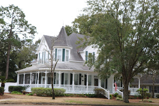
The house is Federal design, which was not typical for this area.  Notice the green shutters on the upper porch that allowed air flow.  This porch was used as a sleeping area in the hottest months. 

Beds were draped in mosquito netting.

Miss Lucy was a bit of an herbalist and treated folks in the area before the arrival of a doctor.

The grounds are quite lovely, with magnolia and oak trees, azaleas, camellias, crepe myrtles and other flowers. In another few weeks it should be even more gorgeous.


Below is the outbuilding that held the newer kitchen.  (The original was on the first floor of the home.)

After the civil war, the plantation dwindled until 1947 when the property became a State Park.  Very interesting tour, but I'm still ticked about Rosedown....

We head south from here, skimming the north side of Baton Rouge and getting back on I-10 to cross the 18.2 mile Atchafalaya Basin Bridge through swampland.  From there it was a pretty uneventful drive home, battling the ongoing and seeming perpetual construction and traffic on this road.  ( Beth hates this road, but Greg was driving and she just tried not to watch.)

We arrived home around 5:00.

  As Dorothy said, "There's No Place Like Home".


2/21/22 Apalachicola, Port St. Joe, Defuniak Springs and I-10W


 2/21 Monday

Temperature is 45 degrees this morning as we watch the sun come up at our campsite.

We head back to highway  95W to Apalachicola, a small town almost surrounded by the water of Apalachicola Bay and the river of the same name.   Between 1513 and 1763 this area was under Spanish jurisdiction but occupied mainly by the Apalachee, Miccosukee and Timucua tribes.  From 1763 to 1783 it was under British West Florida and had a trading post called Cottonton.   The town was incorporated in 1837 and occupied by Union forces for most of the Civil War.  We stop at the Chestnut Street Cemetery whose markers go back to the early 1800's.  There are 79 Confederate soldiers buried here as well as 7 Union. Many interesting stories of the early settlers.

Also in Apalachicola, we stop at their Vietnam Veterans' Memorial - a nice bronze statue depicting 3 young soldiers. 

This marina had an interesting decor and lots of pelicans and gulls. 

 There is a church from 1837  which claims to be the earliest pre-fabricated building, as it was built in the north and shipped here to be put together with wooden pegs. 

There are several old homes and mansions to tour, but we opt to continue on to Port St. Joe.

This is the Cape San Blas lighthouse in the small town of Port St. Joe.  Originally brick and located near some dangerous shoals at nearby Cape San Blas, it has been moved several times due to erosion and storms, and once due to being burned by Confederate troops.  This skeletal version was deactivated in 1996 and finally moved to this location in 2014. Nice park nearby with an occupied osprey nest.  We saw a similar lighthouse back before St. George's Island.  They are supposedly better in winds and storms and can be stabilized on a concrete foundation.

 From here we leave the coast and wind our way north to Defuniak Springs, where we'll catch I-10. Defuniak Springs has a lake in the middle of town which is surrounded by a park and some beautiful victorian homes. These were originally built with railroad money. 

 The path around the lake is obviously popular for running/walking and this house was so kind as to put a water fountain by the sidewalk, complete with a pipe leading to a dog bowl!   

Once we get on I-10, we are back to Central Time Zone.  We reach Mississippi about 3:00, then Louisiana at 4:15. 

 We decide to stop at a Walmart in Hammond, LA. off of I-12.  Dinner is tuna salad sandwiches and leftover shrimp.

Wednesday, March 9, 2022

2/20/22 St. Mark's, St. George's Island, Tate's Hell St. Forest, FL

2/20 Sunday

31 degrees this morning at 7 AM.   We pass a few more smaller sinkholes on the way back to paved roads and take 98 west to Lighthouse Road and St. Mark's National Wildlife Refuge.  We come to the entrance, free with our passes, and a large Visitor's Center and an Education Center which are closed.  Too bad because we've read that they are worthwhile.

The refuge covers 70,000 acres so we have a bit of a drive to the lighthouse, but it is through some beautiful wetlands with quite a few birds!  It has warmed up, though windy, and the sky is a gorgeous blue. We join several cars and a few photographers with huge lenses, stopping here and there for photos.

Mostly herons and egrets with a few cormorants, ducks and ibis.   We are wondering if we are still in gator country when Greg spots one sunning, which answers that question.  There is hiking and fishing available too, but most people just seem to be birding or sightseeing.

The road ends at St. Mark's Lighthouse and we park and do some walking here.  The lighthouse is 82' high and was built in 1833, then re-located in 1842.  It is visible from 19 miles offshore.

Notice the bird and it's shadow against the lighthouse in this picture?

Beth wonders along the water's edge and notices some splashing going on.  There must be a school of fish here because the pelicans and some other birds are repeatedly diving into the water.  And then she notices some fins when a few dolphins join the feasting!  How cool!  

I watch for a while and talk with some lucky women who live near Talahassee and come here often. 

Then I find Greg and we explore a bit further in the Trek,  and begin the drive back to 95. What a beautiful place!

We next stop at Wakulla River Park which was written up somewhere as a cool place with a boat ride.  It seems to have fallen on hard times, though, and while a fine place for a picnic, the dock is falling apart and we see no boat.

Back to 98W.  We pass some more stands selling boiled peanuts and laugh because Yvonne, being a Yankee, told us she thought people were saying "bald" peanuts for the longest time.  (We tried them on another trip and opt to pass on this southern treat.)

Next stop is St. George's Island, one of Florida's Gulf Coast barrier islands.  9 miles long, it is 4 miles offshore and reached by a long bridge that was completed in 1965.  We stop at the lighthouse first which was only decommissioned in 1994 after operating for 142 years!  

We drive the length of the island, part of which is developed - somewhat - 

 - and part a State Park.  Sand and dunes and probably some nice beaches in warmer weather! There is a campground out here too and several picnic shelters on the beach. The sand is very fine and nearly white.

We head back across the bridge and stop at the Family Coastal Restaurant that we had noticed earlier for some more seafood.

An older building with a nice covered porch area where we enjoy some great seafood.  Beth goes with the shrimp, which our waitress said were peeled earlier today. They are superb! And fried green tomatoes as a side. 

  Greg gets a Sea Monster Po'boy, which has grouper, shrimp and scallops on it!  

There are two seafood processing places next door and this mountain of shells.

 From here we take 65N toward some State Forest campgrounds.  But shortly we leave the paved road to follow a sign to the Ralph Kendrick Dwarf Cypress Boardwalk.  Never heard of Dwarf Cypress trees before but there are lots of them in the few acres around the boardwalk.

I think of swamp water being murky and yucky, but this seems to be clear and fresh.

 Leaving the boardwalk, we follow another sign to Rake Creek campground which is one of the ones mentioned on Campendium in Tate's Hell State Forest.  It consists of 1 picnic table, 1 fire ring and 2 cleared sites.  The self-pay kiosk is history, but it seems a terrific spot. 

 There is a small stream behind us and a short walk to a river.  Not sure which is Rake Creek. 

 Beautiful sunset.  Quiet night.