Search This Blog

Monday, August 10, 2015

Aug 4, 2015 North Dakota, South Dakota

Tuesday, August 4th

North Dakota to South Dakota

This morning we headed south on Hwy 85.  Lots of truck traffic and more motorcycles as we head toward Sturgis, where the annual motorcycle rally began yesterday.  We have decided to forego the Black Hills and Custer St Park area, even though we like it, because of the crowds – they are expecting a million people!

We pass several huge sunflower fields and Greg reads later that they are a good rotation crop, replenishing nitrogen. They have a special harvester that collects the heads/seeds. 
We have seen many bee boxes throughout Montana and again here.  Lots of wheat fields too, along with the hay.


We decide to take the Enchanted Highway, a highway along which several large “art” masterpieces are displayed. Billed as the world’s largest metal sculptures, the first one “Geese in Flight” is huge. 
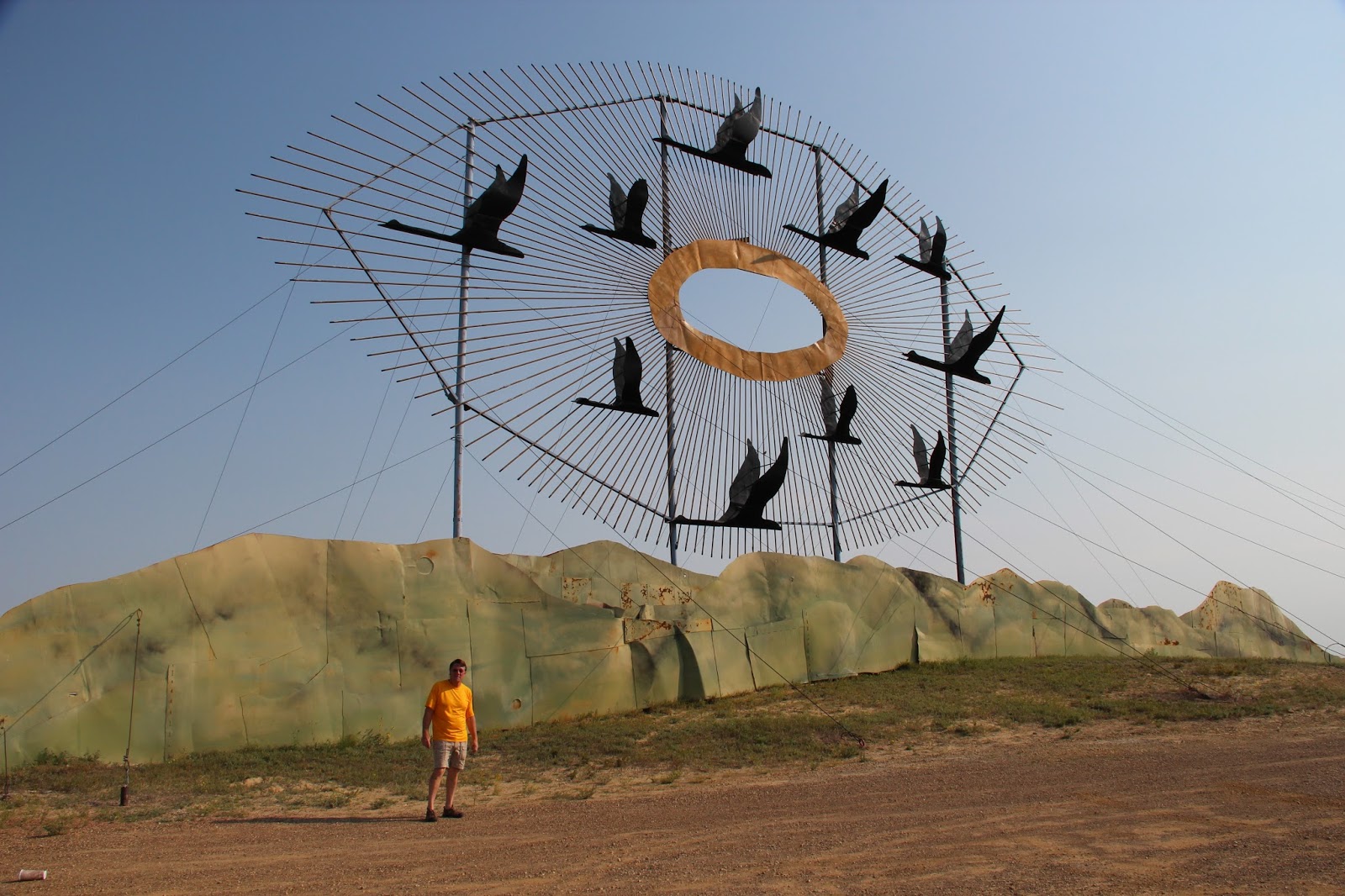
The sculptures are all made from oil field and farm equipment scraps.  Gary Greff of Regent, ND started it all in 1992.


People here are so polite – we have come across several sections of roadwork where there is a single lane.  There is a stop sign for traffic each direction and under the stop sign it says “Take Turns”,  kind of like “Play Nice”.

We reach South Dakota at 11:00 AM and decide to stop in Buffalo.  We called ahead and their library is open today and has wi-fi, so we will pause for gas and chill a bit. The library is very small and only open 2 ½ days a week, but the librarian is nice and their wifi is good.

The Trek has been running rough, particularly at low idle, so we get a recommendation from the librarian and stop by to see “Tim”.  He takes time to listen and says it sounds like dirty injectors and suggests an additive and using high test gas for a while. 

We add some Sea Foam and go back about 20 miles to a small section of the Custer National Forest where we noticed a campground sign.


  Turns out that Reva Gap Campground is a great free spot that has about 10 large sites and no campers. Lots of rocky outcroppings and tall pines.

Good breeze makes it comfy and Greg is able to find wood for a campfire later on.  We do a few short hikes,  take outside showers and settle in for the evening.

Around 9PM we can see a storm to our west and south.  Wind shifts but we get no rain and enjoy an impressive light show!  Lightning is almost all close to the horizon and is very bright white and nearly constant! No thunder.  An occasional fork from the clouds is almost blinding! Continues for quite a while as we go to sleep.

I wake a few hours later and the storm is gone but cloudy sky means no stars.  I drift back to sleep listening to the yipping of coyotes.

Monday, August 3

52 degrees at 7:20.  We decide to complete the scenic loop this morning and within a few minutes come across several groups of bison wondering along and across the road.  They don’t seem half as intimidated by cars as we are by them.  Even the young ones will pause in the  middle of the road until the spirit moves them to amble on.
Wanna play chicken?

There are wild horses in this area too, and we watched as several horses nudged a few young bison away from the spot they are grazing.  That brought a quick reaction from a few nearby adult bison  and the horses quickly moved away.


Next we pause to watch the prairie dogs.  I sat on a bench about 5 feet from this little fellow who chirped an alarm every time I moved.  I could probably see 25-30 burrows from my bench.


Their chirps sound like a doggie squeeze toy. The area looks like a moonscape with many craters where their holes are. Some seem to be in family groups and these two wrestled and carried on.


Moving on down the road, there were many interesting rock formations.  A hard caprock covered some of the sandstone, protecting it from erosion, which resulted in odd toadstool like formations called hoo-doos.  Various layers of color added interest too, as well as cannon-ball shaped concretions embedded in softer rock.


We completed the loop and went to the Visitor’s Center to watch a film called “Refuge of the American Spirit” about this park and Theodore Roosevelt.  Roosevelt lost both his wife (in childbirth) and his mother (Typhoid) the same year, and came to this area where he worked on a ranch while recovering.  He returned to New York, remarried and eventually became president when President McKinley was assassinated (much to the chagrin of those who elected him vice-president to keep him out of their hair!) He was later instrumental in preserving this and other areas, as well as sending 10 of the disappearing bison to the Bronx zoo for breeding.  Many of those in the west today are descendants of those 10.

There is a northern unit of the Park, about 70 miles north and someone had told us not to miss it, so we headed that direction.  It was still early in the day, so we continued past the park to Fort Union Trading Post which was an important Fort and Fur Trading Post on the Missouri river (which has since changed course).


A replica of Bourgeois House, built by John Jacob Astor who founded the American Fur Company, is within the fort.  250,000 buffalo robes and $100,000 in merchandise traded here annually between 1828 and 1867.

We met a photographer from France, Bruce Soyez Bernard, who was traveling the country for two months.  He did mostly photos of people, with accompanying short stories.  He had been to Sturgis and showed us a few of his photos.  He has lived in New York for a while, so his English was quite good.  Interesting chat. We’ll check out his facebook page...and we invited him to come by our house on his return trip via the South.

Came across this Ukranian Catholic Church, built in 1906, in the middle of the prairie.

There is quite a bit of agriculture in the area, with sugar beets and wheat being popular.  There is also quite a bit of oil activity the further north we go, with many jack-up rigs pumping away.  It wasn’t uncommon to see one or more rigs in the middle of a wheat or hay field. The flare-off fire near the rigs is burning off gasses.


There used to be quite a shortage of oil field workers in this area and many come here in trailers and campers to work for a season or two.  Some housing was empty, as we heard that when oil prices fell, many were layed off.  But we still saw crowded rv parks and inexpensive housing units or manufactured homes.
One sign advertised a Summer special rate of $649 per week for 1 ½ bedrooms.  There is basically nothing in the area and winters are long and brutal so the pay has to be good.

We double-back to the North unit of TRNP and choose campsite 28.

We have mac ‘n’ cheese and ham for dinner, and then take a ride out the 14 mile road of the park.   Much the same as the south, we see bison, deer and wild turkeys and lots of dramatic rock formations and overlooks. This one is Riverbend Overlook. We could see  a bison and wild horses in the distance.

Small pavilion built by the CCC at another overlook

The setting sun was an orange fireball but set over grassy fields rather than the canyons and spires.


Note: overall, we think a visit to the southern unit would have been sufficient since we didn’t really see much different in the north.


Sunday, August 2
Bighorns to Little Bighorn to N. Dakota

51 degrees this morning as we finish crossing the Bighorns and reach prairie land again. As we near Buffalo, we see a red fox cross the road and a few moments later another, feline-looking, critter. I keep thinking bobcat or lynx but I’m not sure what lives around here. Definitely larger than a house cat, but it moved so quickly we can't be certain what it was. A few early morning deer  and pronghorns as well. Looks like they are losing their velvet.


Gas in Buffalo is $2.69 – the lowest we have seen in a while, so we fill ‘er up!

Through rolling hills and prairie land, we pause at Fort Phil Kearny – what’s left of it after the Cheyenne burned it. 

It was an outpost meant to protect travelers to the gold fields but only functioned for a few years.  Mostly a base for battles with the Sioux and Cheyenne, who didn’t like the white man breaking promises and taking their land.

Speaking of which,  we are back in Montana and our next stop is Little Bighorn Battlefield, site of Custer’s last stand.  It is dedicated to warriors both from the US Army and from the Cheyenne and Sioux, and is well done. 


Sculpture at the Indian monument
There are markers throughout the Battlefield marking where soldiers and/or Cheyenne died, and two large monuments memorializing all who died here.  The area is very hilly so it is easy to see how the various divisions became separated.

We arrive just in time for a Ranger Talk.  Steve Allison, an ex-teacher and great storyteller, spent over half an hour talking about the battle, its strategies, its causes and results. 
A few highlights:
 42% of the US soldiers were foreigners, mostly Irish & Germans.
 263 soldiers and 60 Indians died this day.
 In 1840 there were 60 million buffalo in the west and by 1890 there were fewer than 500.  Since they were the “walking Walmart” for the Indians (food, clothing, tools, etc.) this unbalanced the Indian way of life. (Some say this was a deliberate plan by the whites.) This battle marked the end of the Indian way of life.  A year later Crazy Horse had surrendered and after a few years in Canada, Sitting Bull returned and was arrested, though allowed to tour with Buffalo Bill Cody and visit Washington, etc.
Both Custer and Sitting Bull had been aggressive warriors throughout their lives (lots of testosterone!) and showed it here. Neither expected to lose.
There is a memorial to the horses that died here too, when, as a last ditch effort, Custer ordered the horses into a circle around last stand hill and killed them for use as breastworks.

5,000 soldiers not associated with the battle are also buried here, as it is a National Cemetery.

We left the battlefield and continued on towards Theodore Roosevelt National Park in North Dakota.  Went through Cheyenne Indian Reservation and a town called Lame Deer, home to Chief Dull Knife College.

Arrived at the South Unit of TRNP and checked in at the Visitor’s Center.  We found a campsite at Cottonwood Campground – a National Forest Campground, so $7 for us.
After dinner, we drove part way around a 36 mile scenic loop through the park. 

Saw a few bison, pronghorns, deer and hundreds of prairie dogs. Walked the trail at Wind Canyon – nice views! Some interesting rock formations too.


Campsites are rather close together and have no fire rings, just fire boxes on posts. By evening the campground is full.  It is too warm for a fire at any rate. A comfortable sleep with just a sheet for cover as the temp gradually falls to the 60’s.


Tuesday, August 4, 2015

Aug 1, 2015 Eastern Wyoming

Saturday, August 1, 2015

Sunny and windy start to the day.  52 degrees this morning as we head back toward Greybull where we stop for coffee and doughnuts. We ask at a gas station if there is a bakery in town and get a strange look and comments that maybe there is a small one a few towns over.  So we go back to Blair's grocery store where we shopped yesterday. 

 We are back to desert land except for those that irrigate.  Some cattle and sheep, some green farmland contrasts with the rocky mountains and brush covered desert.  We are heading back to the Bighorns and turn east at a town called TenSleep. It was 10 sleeps (nights) between southern and northern Paute villages.  Now on the Cloud Peak Skyway toward Buffalo.

More trees as we climb back into the mountains.  
We stop at TenSleep Fish Hatchery and see tanks of trout, mostly rainbow and cut-throat, of varying sizes. They produce about 1.2 million eggs a year, some of which are sent to other hatcheries for rearing.


We continue on the Fish Hatchery road which turns into a dirt road that meanders through the mountains till it rejoins 16.  Quite a few boondockers along this road.

Quick stop at Meadowlark Lake which has a monument to the CCC (Civilian Conservation Corp) which built the dam at this lake, as well as many bridges, cabins, watchtowers, walls, etc. throughout the country between the early 1930’s and 1942.


James T. Sabin Lookout is our next stop, up a dirt road and then a trail through a rocky forest to the top of a mountain. 


View from the tower showing the road we came on.

Talk with a older couple there who are traveling with a kayak and a dog from Midland, TX and are heading east – as in all the way to Maine!

We are drinking like crazy today and our skin and lips are parched. When I take fresh bread out of the package, it is already drying before I finish making sandwiches! 

We go over Powder River Pass at 9,666’ and begin a slow decent.   Today is also a very warm day, so we opt to stop early and camp for the night at a high elevation rather than go back to the desert/prairie.  Lost Cabin is a national forest campground where we find a site among tall pines. 


We haven’t had a fire for a few days so Greg collects and cuts some wood for this evening.  Beth gets caught up on the blog, though we’ll have to wait for wi-fi to publish anything. We wander through the woods and Greg finds a few interesting rocks.

We invite the single woman in the next campsite to join us.  Her name is Royce and she is from Maryland, on her way to Seattle where her daughter is due to give birth in a few weeks.  She has a rig similar to ours (Leisure Way) and though this is her "maiden voyage" she seems quite confident and comfortable.  An ex-teacher and school administrator, she has some interesting tales. We exchange stories and have a pleasant evening sharing her raspberry merlot.