Search This Blog

Thursday, July 25, 2019

July 17, 2019 Colorado back to Texas

Wednesday, July 17

This morning is cool and clear - 52 degrees.  149S is called the Silver Thread Scenic Byway, and Scenic it is.


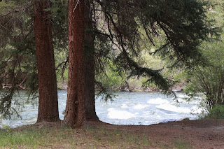
The river we camped by is the headwaters of the Rio Grande.

We stop to read about another mine - Clay Mine, which mined something called bentonite used in refining oil and in ammunition during WWII.

Unfortunately, the road also passed miles of dead spruce and pine trees, devastated by the pine bark beetle.  The pines and beetles always had a relationship but the beetles have flourished (some think because winter temperatures are becoming milder and not killing them).  The trees can handle some, but not recent numbers. Non-evergreen trees aren't affected and so aspen are taking over some areas.
We have seen this problem from Texas to Canada.

We've been looking for Forest Road 510 to a waterfalls, but when we get to Creede we find out that we missed it 25 miles ago.  We stop at a place called MJ's for a hearty breakfast - popular spot and good food. Consider hunting for some amethyst in the area, but a book says it is pretty much all picked over, so we pass.  Besides,  home is calling to Greg...

A few more passes and we are in New Mexico again and by 7:30 we reach Texas and the Central Time Zone.  We continue on to Amarillo where we stay at a Days Inn which is comfortable.  Too tired for dinner, we shower and hit the hay.

Thursday, July 18

Today is a long travel day back to home.  Too hot to make stops at Palo Duro Canyon and other interesting spots in the area.  Beth does some computer work and then snoozes while Greg soldiers on...  West Texas has A LOT of wind turbines and we notice a few signs here and there protesting them.  We google it and as best we can tell the anti-wind people don't like the visual obstructions.  Sometimes birds get whacked.  But most of the objections seem to be from the supporters of fossil fuels.... hmmm.  I'd rather see a wind turbine farm that coal plants belching pollutants!

A sure sign we're near home...

Home again home again and we nearly dance a jigged jig.

We lower the thermostat and once the house cools down it is good to be home.  3,050 miles.  Wishing there was a cooler place closer to home!  Wishing Scotty could "beam us up" to Colorado again!


July 16 Black Canyon of Gunnison, Colorado

Tuesday, July 16

63 degrees this morning as we continue on our back road, now number 858.  There are signs warning about work delays, but we hit it right and barely pause.  We travel through more aspen and other forests,


 passing several pretty high meadow alpine lakes - Silver Lake, Beaver Lake (no beavers).  The Trek again has overheating issues due to long climbs, but as long as we stop for a bit to cool off, all is well.


These horses were lined up watching the road work!

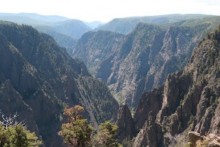
We finally reach Highway 50 and head for Black Canyon of the Gunnison National Park.  We have been here once before but will visit some different areas this time.  Beautiful!  This is the greatest combination of depth, steepness and narrowness of any canyon in North America.  


This is called the Painted Wall - pegmatite stripes in gneiss.


The canyon is 48 miles long and 2,000' deep and grows deeper by about an inch in a century!  Mind boggling to think how long it took to get where it is today!  The Gunnison River has carved this marvel which was first explored in 1853.  In 1909 they drilled a huge tunnel 8' high by 10' wide through the canyon wall to divert water to farmers in the area. President Hoover created the National Park designation.

We decide to start heading east and south from here - back towards Texas.   We pass a beautiful campsite along the Lake Fork of the Gunnison River and turn around to take a look at Gate Campground.  Only 5 sites and two are taken, but we choose site #2 which is far enough from the others that we can't see or hear them.  This is a Forest Service campground for which we pay a whopping $2.50. Greg cooks burgers on the grill tonight after doing a wash-up in the river!  He scrounged wood for a fire, but the mosquitos are too bad to spend a lot of time outside.


Wednesday, July 24, 2019

Monday, July 15 Durango-Silverton Train, Ouray, Back roads

Monday, July 15

We head out early today, headed for Rockwood where we'll catch the train.  Instead of taking the entire route from Silverton to Durango, we have opted for a shorter train ride from Rockwood to Cascade Canyon and back - a two hour trip.

We cross Molas Pass (10,910') and beautiful scenery on the way, but we'll come back this way at a more leisurely pace.


 Rockwood is a tiny place with the train station being the main feature.  We arrive early and have a leisurely breakfast and watch a couple of trains come through.


The Silverton-Durango, or Durango-Silverton narrow gauge (3')steam engines have been operating continuously for 138 years.  They are narrow gauge because it is easier to lay track, easier to make curves and such so that they don't need tunnels through the mountains.

Beautiful scenery through mountains, canyons, alongside a wild Animas river in the San Juan National Forest.


 Some places the clearance between the train and rock walls is only 8-10"!

 The crew - conductor, brakeman, and tour guide/snack peddler Josh are all pleasant.
 We are in an enclosed car with 22 wooden bench seats - 44 people. There are four other cars and all seem pretty full today. Pleasant ride, beautiful day and beautiful scenery!

The train returns to Rockwood at 1:10, and we head back north on 550.  This is part of what they call "The Million Dollar Highway" (due to the cost when it was first built).  Lots of steep grades, switchbacks and narrow roads, often without guard rails!  But amazing scenery.


This picture is from Coal Bank Lookout (10,640') where we stop for a bit.

We stop again at the site of Yankee Girl Mine, one of the richest silver mines ever,  discovered in 1882.  It closed in 1898 and these remains linger on. The mountains are scarred from the mining but signs say they are being remediated.


This is Bear Creek Falls - the ripple marks in the rock next to the falls were formed by moving water when this land was horizontal rather than vertical!

We stop in Ouray and visit Box Canyon Falls on the edge of town.  A unique waterfalls deep in a rocky box canyon.


Black swifts migrate here from Brazil every year....here is a nest along the canyon wall with egg.

Lots of cute chipmunks in the area around the visitor's center.


We visit main street for a little shopping and go to Maggie's for dinner, recommended by a young man in one of the stores.  OK place but really just sandwiches and a few sides - you could skip this one.  Here's a look back at the town, nestled among the mountains.


From Ouray we continue north towards Owl Creek Pass for a camping spot for the night.  County Road 10 to County Road 8 - gravel, but quite well maintained. We wind through some beautiful aspen forests - must be an even more amazing site in the Fall!

 We find a nice large open space off the road and stop here for the night.


We chat with Ron from Denver, who is also camping here - he just left his job and place in Denver and is looking for a house out here "away from the craziness" of Denver.

Nice wildflowers along a short trail


and beautiful moonrise!